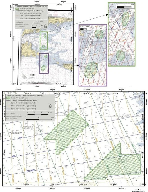
GEOTECHNICAL SURVEYS
Geotechnical surveys will take place in Vineyard Wind Lease Area 522; the southern portion of Vineyard Wind Lease area 501, and between the Lease Area 501 and Cape Cod, including Muskeget Channel and Nantucket Sound. Please see reverse side for chart of survey area. Please check in with the contact below for the latest information. Collecting data and working with the local fisheries, Vineyard Wind is committed to communicating and working with the local fishermen in the region during all stages of development of the proposed offshore wind farm. Information gathered will be used to further design the wind farm and refine the location for the cable route from the wind farm to shore. In advance of and during survey operations, we seek contact with fishermen who are or may be working in the survey area. Please see reverse side for chart of survey area.
Survey activity will begin on October 16th and continue into Mid-November pending weather.

R/V Shearwater
LOA: 110 feet
Flag: USA
Bridge VSAT
Phone: 201 297 6015
Email: wporter@alpineocean.com
Standing by on VHF Channel 16 & 13
For the latest information, please contact:
Caela Howard, Fisheries Liaison - Cell: 617-999-3882 • Email: caela.howard@avangrid.com
John Harker, Lead- Fisheries Outreach Coordination - Cell: 857-216-8611 • Email: john.harker@avangrid.com