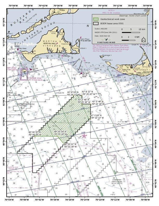
GEOTECHNICAL SURVEYS
Vessel DINA POLARIS will be conducting geotechnical surveys in the northern portion of Vineyard Wind Lease Area OCS-A-0501.
Vineyard Wind is committed to communicating and working with the local fishermen in the region during all stages of development of the proposed offshore wind farm. If you are fishing or plan to fish in the survey area during this time period, please contact our Onboard Fisheries Liaison or a Vineyard Wind Fisheries Liaison with any questions or comments
Date(s): Beginning on or about November 4, 2020.
Estimated completion: Late-December
Location(s): The northern portion of Vineyard Wind Lease Area (OCS – 0501)

Vessel: DINA POLARIS
LOA: 324 foot
Flag: Norway
Email: captain@dinapolaris.mmred.no
Sat Phone: +47 479 702 26
Standing by on VHF Channels 13 & 16
Onboard Fisheries Liaison: Mathew Thomson
For the latest information, please contact:
Caela Howard, Fisheries Liaison - Cell: 617-999-3882 • Email: caela.howard@avangrid.com
John Harker, Lead- Fisheries Outreach Coordination - Cell: 857-216-8611 • Email: john.harker@avangrid.com