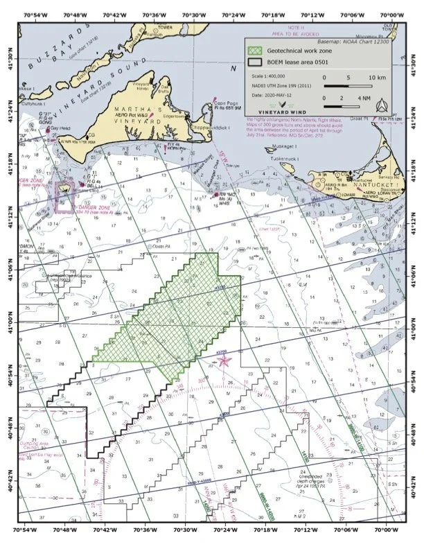
GEOTECHNICAL SURVEYS
Geotechnical surveys will take place in the northern portion of Vineyard Wind Lease Area (OCS-A 0501) beginning on or about May 20, 2020. The 264 foot survey vessel GEOQUIP SAENTIS will begin operations in May and is expected to continue survey operations for 4-6 weeks.
Vineyard Wind is committed to communicating and working with the local fishermen in the region during all stages of development of the proposed offshore wind farm. Please contact the fisheries liaison if you are fishing or plan to fish in the survey area over the duration of the survey period.
Date(s): Beginning on or about May 20, 2020. Estimated duration 4-6 weeks.
Location(s): The northern portion of Vineyard Wind Lease Area (OCS-A 0501)

GEOQUIP SAENTIS
Port: 264 feet
Email: master.saentis@geoquip-marine.com
Phone: +47 236 75053
Standing by on Channel 13 & 16
For the latest information, please contact:
Caela Howard, Fisheries Liaison - Cell: 617-999-3882 • Email: caela.howard@avangrid.com
John Harker, Lead- Fisheries Outreach Coordination - Cell: 857-216-8611 • Email: john.harker@avangrid.com