
GEOTECHNICAL AND GEOPHYSICAL SURVEY
Geotechnical and Geophysical surveys will take place in the southern portion of Vineyard Wind Lease Area (OCS-A 0501), and along a small corridor of the northern portion of Vineyard Wind Lease Area (OCS-A 0501) beginning on or about July 9, 2020. The survey vessel LEEWAY ODYSSEY will begin operations first, followed by the EGS VENTUS.
The survey vessel LEEWAY ODYSSEY will be calibrating a gradiometer on the way to the survey area on July 28/29. e calibration location is in Vineyard Sound South of Woods Hole. e operation will take them back and forth across the cable area north of Middle Ground, an area with known magnetic targets (highlighted in green on the attached chart). e gradiometer will be towed approximately 10 to 20 feet above the seabed, between 350 – 650 feet off the stern of the ship. Once calibration is complete, they will proceed to the Lease area.
Location(s): The southern portion of Vineyard Wind Lease Area (OCS-A 0501)
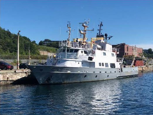

Vessel: LEEWAY ODYSSEY
LOA: 125 feet
Flag: Canada
Email: Bridge.Odyssey@leewaymarine.ca
Phone: 1-902-701-2240
Onboard Fisheries Liaison: Scott Garvey 401-447-0647
Standing by on VHF Channels 13 & 16
Vessel: EGS VENTUS
LOA: 164 feet
Flag: Marshall Islands
Email: captainventus@egssurvey.co.uk
Phone: 1-646-740-0123
Onboard Fisheries Liaison: Lynn Gurchik 774-634-6337
Standing by on VHF Channels 13 & 16
For the latest information, please contact:
Caela Howard, Fisheries Liaison - Cell: 617-999-3882 • Email: caela.howard@avangrid.com
Caela Howard, Cell: 508-386-9832 • Email: Choward@Vineyardwind.Com

